Categories
exploration hiking history nature travel

no fish to kolka

closeup shaky photo of a dirt by Nicholas Orloff

The Sony A77’s swan photo.

This photo of a dirt road is the last I took before a travel photographer’s worst nightmare struck. During a cold-stomached panic, all efforts to revive my camera were futile and for reasons I will never know, it was toast. With help out of reach, I strapped my substitute photographic device (iPad) to my chest and continued pushing through the forest like a grizzled woodland teletubby.

For as long as I remember, I’ve had a love of fishing. At our family house in the remote woods of upstate New York, my father and I would hike to a lake through the woods and we’d fish away the afternoon. Later in life, whenever I was in the need of peace or a freshly caught meal, I’d drive up there, walk through the forest and sit by the water with my rod and thoughts.

So when I read about the Livonian coast in north west Latvia, an 80km stretch of unspoiled coastline dotted with 12 historical fishing villages, I just had to go. It’s been a decade since I’ve fished, but I could experience it vicariously. I would walk the entire way, stop at each village, eat fish at ramshackle seaside cafés, chat with locals and learn about their traditional way of life. Perhaps, just like when I was young, one of the old fisherman would let me ride in their boat and cast a line or two.

The day before, my spirits were high when I left my starting point in the city of Ventspils. I marched northwards through the hot sandy beach of the Baltic sea, sweating and aching but excited. 15km later, I reached the first village of Liepene and spotted my first fishing boats. But none were at sea, but dragged up on shore, seemingly decades ago and left to bake in the hot sun like tombstones marking the old way of life.

150828-nofishtokolkalatvia-blog-1

Photo taken with Sony A77, by Nicholas Orloff.

Old boat and fishing/farm equipment left out on land. By Nicholas Orloff.

Photo taken with iPad.

There was no fishing going on.

Not in Liepene, or the next village of Targale, or Luzņa after that. I felt stupid. How could I not have known? What happened? My dream of experiencing the simple fishing life swam away. Then the following afternoon the camera tragedy struck. A fleeting thought of quitting and returning to Riga flew through my head—this journey was pointless. And walking along the sea in the deep sand was too tough with heavy boots, and there was nothing for me to discover here.

But the wild Latvian forest hugging the beach beckoned me with a promise of a fresh start—a long walk with nothing to photograph and to reminisce those days long ago walking through New York forests with the fishing lake at the end of the trails as my reward. Fishing was no longer a reward here, but the seaside at Cape Kolka was. Close enough.


 The north western Latvian forest is wild and unmaintained. I quickly found the trails are tricky—often they narrow before trees swallow them, leaving me no choice but to cut through the wilderness without a path to follow.

An overgrown path disappearing into a thick forest. By Nicholas Orloff.

Dead end. Photo taken with iPad.

The soft static white noise of the Baltic Sea’s waves crashing into the coast far to the west proved a more reliable means of navigation than a compass. Often turning back was not an option. Confusion sets in as I turn around to backtrack and find two paths forking out behind me. The forest spins around and folds in around me, like it’s sucking me in and thwarting exit. The loneliness of this forest was a lie and I was convinced that something was always watching me. I keep moving,  sweating from the humidity and inventing dangers in my mind, and just when I’m questioning the ability to leave, the trail gives way to an incongruously placed road.

An old forest road very overgrown with grease and plants. © Nicholas Orloff Photography.

Road to nowhere. Photo taken with iPad.

Overgrown with grass and weeds sprouting tall from the disintegrating pavement, it’s clear that neither feet nor wheels have beaten this old road for weeks. Who built them, I wonder, and why here?

By the end of my second day, having slept in an empty campsite the night before and rationing cheese, bread and dried meat carried from Ventspils, my chemical repellent soaked face slices through clouds of hungry mosquitos as I push forward. In my discomfort, I keep telling myself that barring severe injury, victimization by crime or arrest, it’s impossible to have a trip ruined. You can’t control what gets thrown your way.

But you can control your mindset. I let fishing and photography drop from my mind. And then something interesting happened.


By the third morning my senses heighten­ed. I zeroed in on the scent of the forest–wet, fresh dirt cleansed by the wind from the sea filtered through the tangle of trees. Another reminder of my childhood summers in the woods, the smell of freshly dug gardens that old Russian ladies kept on their front lawns, lining the the rough gravel road in the forest that my grandfather’s generation built their dachas on. But those old ladies, and the rest of that generation, are gone. And their gardens and homes are reclaimed by the forest.

I couldn’t shake the idea that everything eventually becomes a graveyard. Not because I’m morbid, but because what I found—an old military bunker sprouting from the forest carpet undergrowth like a mushroom. Or a tombstone.

Munitions storage bunker. Photo taken with Nicholas Orloff's iPad.

Military mausoleum. Photo taken with iPad.

I knew that Latvia was subjected to countless invasions, occupations, resettlements, crusades and wars. But I did not expect to see any evidence of this in the middle of the woods.

Was a war actually fought here? Can there be soldiers’ skeletons hidden just beneath the brush? This was the type of place you could find a body that’s been hiding for months, maybe years. And speaking of bodies, what if I fell and broke my leg? Nobody would find me, for nobody would be able to hear me. But that wouldn’t matter, because there were no people here—I haven’t seen anyone for two days.

As I moved, more tombstones, mausoleums and skeletons appeared.

150828-nofishtokolkalatvia-blog-12

Watchtower. Photo taken with Nicholas Orloff’s iPad.

Inside an abandoned structure in the forests of western Latvia - by Nicholas Orloff

Structure of unknown origin and purpose. Photo taken with Sony A77.

Photo of a gunner's nest in the forests of the Livonian Coast. By Nicholas Orloff Photography.

Gun nest. Photo taken with Sony A77.

This stretch of coastline and the forest behind it was indeed a graveyard, for a war that never happened.


Later, I learned from locals that the Soviets militarized this coast after they reoccupied Latvia from Nazi Germany in 1944. They built a base and surrounded it with missile launchers and watchtowers. They carved a network of roads through the forest to move equipment and tanks.

Why? Because Cape Kolka was strategically important for it guards the Irbe Strait, the entrance to the Gulf of Riga. The Latvian coastline was now a USSR border and thus became a pawn in cold war paranoia, needing protection from possible invasion. And to aid that cause, many Livonians were forced out or deported to make way for the military. Those who were left needed special permits to enter and leave and the coast was off limits to anyone else. Restrictions on sailing rendered the Livonians’ boats useless for their intended purpose. So they dragged them back to their homesteads and they remained as tombstones marking the old way of life ever since.

And this is how the fishing died.


At the end day four I punch through tree line to greet the sun and sand I ran from before. Reinvigorated by the cool wind from the dark blue sea, I push through fifty hours’ worth of pain for the final push to Kolka along the beach, passing more clues of the militarized past along the way.

Military truck tied to fishing boat on the beach. © Nicholas Orloff Photography.

Standoff by the sea. Photo taken with iPad.

At the Cape, the sea and trees clash in a battle of erosion. Straddling the front line, with my left foot sinking in the sand of the beach and my right crunching through brush, I walk through two worlds at once, taking my time to circumnavigate the cape in the cool breezy air without sweat or purpose.

Trees crashing into the Baltic sea at the very tip of Cape Kolka. © Nicholas Orloff Photography.

Battle by the sea. Photo taken with iPad.


That evening, after luxuriously bathing in brown gritty well water I rest on the patio of an ancient family farmhouse turned guesthouse, sipping from a mug of yeast sweet kvas and picking at a plate of salty, pungent smoked fish. I muster up the energy for a final walk as the sun starts its leisurely descent, visiting icons of history that survived to carry on traditions to this day.

Russian Orthodox church. Photo taken with iPad. Reminds me of my childhood. © Nicholas Orloff.

Russian Orthodox church. Photo taken with iPad.

When you let go from a story that’s not working, you free yourself to discover a new one. The unintended consequence of my broken camera and abandoned plans was finding a story of unintended consequences—a story of how 50 years of military occupation and isolation kept a forest and coastline pristine and preserved. And today, the Latvian government is keeping it that way, as the Livonian coast is a protected national park for all to enjoy.

And as the sun disappeared below the water line, leaving the Cape in warm, wonderful pink and purple light, I finally found who and what I first set out to find.

Man fishing at Cape Kolka, Latvia. © Nicholas Orloff.

Alone with rods and thoughts. Photo taken with iPad.
Categories
exploration hiking travel

the road to sarybash

1508-roadtosaribas-blog-titlepic-womenvalleyThis was the most the most expensive and hard-earned lunch I’ve ever had. I didn’t pay for it, but I’m in pain and it took over 4,000 kilometres on planes, buses, taxis and on foot to get to it. And here I am in the remote mountain village of Sarybash on the far edge of Azerbaijan, the culmination of a journey six months in the making that all started with stumbling across this place on Google Earth.

Remote inhabited places fascinate me—the farther and harder the reach the better. I need to know who lives there and why. Is it due to lack of better options, or because it is the best option? To get away from everything, or to find something? I can relate to all of these questions, for they all ask the same thing: why do I go anywhere?

No more questions, I knew right away I must go to Sarybash.


It’s not an easy road. The closest town reachable by public transport is Ilisu, 10km away. Then your only options are by horse, 4-wheel drive or on foot. The dirt path twists up and down the sides of a deep canyon and crosses the river twice. Just as you think you’ve made headway climbing, the path plunges cruelly down to the riverbed, erasing your progress.

1508-roadtosaribas-blog-5877thehiddenvillage-

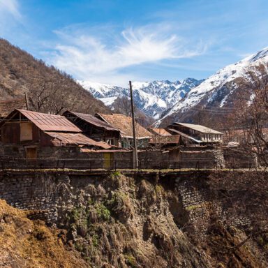
The start of my journey, at the far edge of the canyon, sunlight reflects from a lone building in Sarybash.

Of course it couldn’t be too easy.


But I made it. As I approach the final bend to the village, the gatekeeper greets me. Well, a gate fixer to be precise. He’s fifty or so, a tough looking and unshaven working man dressed for warmth and with three sheep in tow. Before I could catch his name, he starts his interview whilst fixing the gate. “Where are you from? How did you get here? How do you know Russian?” Against my father’s advice (who is convinced everyone wants to kill Russians) I recite my usual answer: my grandparents were Russian and I learned it when I was little. His face brightens and he laughs, telling me it’s funny that an American who lives in England who knows Russian has found his way up there. Yes, I think—it is quite funny. He finishes his task and heads down the hill, his sheep dutifully following him. I wish him a good day, feeling quite surprised by just how un-surprised he was to run into me. This would set a precedent. 1508-roadtosaribas-blog-05485welcomecomittee

I make the final push. The air is chilly, but I am sweaty. Everything hurts and I just want to rest. It’s strange how after you push yourself through so much, you are so wiped out that you forget why you did it.


The guide

At the summit I stumble upon an unexpected expanse of bright green stretching from the cliffs behind me to the Dagestan (Russia) border to the north. It’s called the Tala, which used to be a field for both football and helicopters back in the USSR days.

1508-roadtosaribas-blog-05528-talagreenlawn

Dagestan border—a no-go zone crawling with soldiers, smugglers, outlaws and general troublemakers.

I limp towards a statue overlooking the canyon. Its shadow makes for a perfect resting spot to enjoy the view.

1508-roadtosaribas-blog-05512statue-ilisuview

Far away to the south where the river ends is Ilisu, my starting point.

But a young, casually dressed man pops up, seemingly levitating from under the cliff edge. The sight snaps the tired out of me. And I’m more surprised to see him than he is of me. He is curious and friendly. My Russian is as useless to him as his Azerbaijani is to me. But impromptu sign language and image searches on his phone work well. His name is Mehemmed, which I find out from becoming his Facebook friend within minutes.

Mehemmed

He follows me as I make my way to the cliff edge. We stare at the road I climbed in silence for a while. When I stand up, he stands up too. I know he will go anywhere I go for the rest of the day. And that’s OK.

Mehemmed senses I’m here with a camera and a purpose.

He sees a captures my interest. But he’s not sure why. Because it looks like an abandoned prison hospital, that’s why. So we go in.


The teacher

This bleak, sawdust-stinking place full of faded portraits of mustached military men just had to a relic of the Soviet government. But I was wrong.

1508-roadtosaribas-blog-05532-evidenceschool-desks

My search yields broken desks and dirty rooms littered with yellowed posters displaying the joys of maths, geography and art.

A very large school for a very small town. But no signs of children.

1508-roadtosaribas-blog-5573-mahiresroomThe smell of burning wood grows stronger. Is this place on fire? We find a comfortably shabby room that looks like a museum crossed with a squat. A bed, stove and recently dated newspapers. I’m astonished—somebody lives here. Perhaps an eccentric with a passion for textbooks and solitude?

The occupant swooshes past me from behind, sits at the desk, opens her book and starts scribbling. She’s smiling and smirking, amused by my presence. You can read intelligence by how people themselves read—fast, intense, absorbing knowledge. And it clicks. She’s a teacher. But no, not a teacher—she’s the teacher. The only one.

It’s clear Mehemmed is explaining who I am. I know that she wants to speak with me. But there’s no common language between the three of us. However, I do learn her name is Mahire. She’s interested that I’m interested and shows me without words how the old seismometer on her desk works. She was born to teach.

Mahire, the sole teacher in Sarybash. © Nicholas Orloff.

“Kids?” I ask in Russian. Mahire shrugs.

“They’re gone.”

I remembered it was Novruz, and of course they wouldn’t be there. But from what I was about to learn from Zahir, in some years time what she said will most likely mean something more dire.


Lunch at last

1508-roadtosaribas-blog-05623-gullu-looking

Gullu keeping an eye on Zahir.

Gullu, a lady of about 80, greets us as we pass her window whilst keeping an eye on her husband, Zahir.  She shouts at him to stop chasing cows and come say hello. He is a proud, humorous and warm man, and just from how he shook my hand I’d pick him to be mayor of this village. 76 years old and a fluent Russian speaker, it was welcome to meet someone I can communicate with easily and who could translate as well.

1508-roadtosaribas-blog-05623-zahir-chasingcows

Zahir keeping an eye on his cows.

Within minutes Mehemmed and I are sitting at their dinner table. Their home is a good size, comfortable and warm. The news plays through static on an old 13-inch . I’m surprised they get reception up here. Small talk, chitchat and eating make up the afternoon. Heaps of fragrant rice, fresh baked bread and home made yoghurt, stewed chicken and colourfully pickled, well, .

It’s all delicious and made with care, reminiscent of dinners I used to have with my grandparents thirty years ago. This was home for an hour.

1508-roadtosaribas-blog-05604-dinnertime

Mehemmed and Zahir break bread.

Nicholas Orloff - Having lunch with friendly locals. They are so relaxed, as if they’ve invited strangers into their home hundreds of times. They probably have. He teases Gullu and laughs a lot. He teases me too, asking me if I can dance or sing for them. “Oh Nikolai, Nikolai…” he would say after recounting an anecdote, reflecting on life’s absurdities. He was my grandfather for the hour as well.

Zahir tells me that the people who stay are growing older and the young are leaving sooner, as the country’s capitol, Baku, has too many opportunities. Once over 1,000 people lived here. Now only 100 or so. The only road in or out is eroding and there’s no sign the government will improve it. Work revolves around herding cows and sheep, but it’s not clear how one makes a living from that. Government pensions are about 100 manat (£75) per month. But it seemed like a relaxing and satisfying life—one I could get used to. But I have the privilege to leave whenever I want.

After politely refusing vodka (a dozen times), I leave with a full stomach and with them a promise to them to send their photos.


I am grateful for Mehemmed’s patience for having a friend along for the day was welcome. At my insistence we pull ourselves up a steep hill behind the town, taking care to not slip on the rocks and using slender tree trunks as hand grips. It was worth it:

1508-roadtosaribas-blog-05630-rooftop-viewsaribas2

The view from above Sarybash.

And then we descend to explore the village, covering every corner within an hour. The cold March wind blowing through the empty streets is the only sound we hear.

Thick chimney smoke signals and are the only clues that people live here. I’ve seen a lot of decay in Azerbaijan, from abandoned hospitals to hammans and homes. But there is always new construction nearby. But in Sarybash, and falling apart, a sign this village has been given up on. There isn’t the will or the resource to demolish anything, and if it were fixed, how many would use it, and for how long?

I don’t feel like an explorer here, just someone who had the fortune of experiencing the last of something. Mutual curiosity is a powerful thing; it breaks down barriers whether cultural, linguistic or geographic. The people I met all shared with me the idea of Sarybash before it’s gone.


1508-roadtosaribas-blog-selfie-endIt may seem ridiculous to read that I came all the way to Azerbaijan to spend an afternoon in this place. But Sarybash wasn’t the sole purpose, but the glue holding the trip together. It’s a challenge that gives the journey structure and focus by building anticipation before, and accomplishment for reflection after.

So of course I didn’t travel all that way, go through all of that hassle, spend all of that time and money, and suffer aches, scrapes and bruises simply to have climbed to this tiny village high up in the mountains to chat with strangers I’d never know I’d meet. That would be crazy, I would never do that on purpose for a free lunch.

Or perhaps I did.


Would you like to take the road to Sarybash?
Follow my journey and see photos along the way in this interactive map.

1508-roadtosaribas-blog-05694-largewhitegovernmentalbuilding

1508-roadtosaribas-blog-05595-tippy-statictelly

1508-roadtosaribas-blog-05597-tippy-dontknoweating
1508-roadtosaribas-blog-05670-flag-laundry-signals
1508-roadtosaribas-blog-05666-mosque
Categories
hiking nature travel

the benefits of slow travel: the south downs way

Nicholas Orloff self-portrait - along the South Downs Way.

I took this photo of me all by myself.

You can have an adventure without leaving your country. You can explore, meet interesting people, get lost and see where you live through the eyes of a tourist experiencing for the first time. The trick is to do something radically different from what you do day-to-day in your “normal life”.

In July 2014 I was itching for a trip, but for various reasons going abroad wasn’t practical. So I hiked the entire South Downs Way instead. My wife can’t understand why walking over 120 miles in seven days appeals to me. Well, I have several reasons.

The slower you travel, the more you think about what you see. It’s a bit metaphysical, but you wind up traveling inside your head. You can’t avoid introspection if you’re walking 12 hours a day by yourself. To help you think, you have three things to look at: the ground, the clouds, and farm animals.

1) Below the horizon: the ground
The South Downs Way runs through 100 miles mostly of chalk grasslands, farms and hills. So it’s repetitive. But you quickly learn to appreciate little details that diversify your view:

2: Above the horizon: clouds
Almost any photo can be improved with clouds. Clouds make everything look dramatic. Not only do they keep the harsh sunlight off your subject, they cast shadows, break up the monochrome sky, and refract and reflect light.

Examples:

Dramatic herd of sheep - taken by Nicholas Orloff in summer of 2014.

Dramatic herd

Dramatic gull in the clouds  - taken by Nicholas Orloff in summer of 2014.

Dramatic bird

Dramatic poppies - taken by Nicholas Orloff in summer of 2014.

Dramatic crops

Dramatic rust - taken by Nicholas Orloff in summer of 2014.

Dramatic rusty thing

3: In between: farm animals
If you walk this trail alone (and in my opinion, you should), even cattle start appearing dramatic:

Eventually, sheep and cows start talking to you. It usually happens after walking twenty miles on four hours of sleep.

SDW2014-529

I don’t believe we’ve met.

And who do you think you are?

It’s not all great fun for animals though. You’ll pass right through a pig farm outside of Steyning, East Sussex. Pigs get a bad deal and live in forced labour camp conditions.

SDW2014-939

Dystopia

You start going a bit strange and thinking about how there can’t be beauty without pain, and all of that stuff.

The trifecta

My best photos on this trip resulted from combining clouds and animals with a sharply contrasting foreground. This is epic stuff, and it almost always happens when a storm approaches:

Nicholas Orloff - The South Downs Way Sheep

Dramatic birds
There you have it. Travel slowly, study closely, observe simplicity and find beauty. You know you’re doing it right when strange but wonderful things happen.

It happened to me on the last night of this trip in Alfriston, East Sussex. I was walking back to the hostel after dinner and literally was pulled into an art gallery exhibition before a heavy storm hit. I wound up photographing it for the artists, and got some free food out of the deal. It’s moments like those you find along your journey that you didn’t know you were searching for.

And riding these moments to conclusion sets you up for catching photos like these:

It only took me walking 100 miles over six days to catch this shot.

So what are you waiting for? Get walking!

Bonus:
Play around with this interactive map to follow my journey and see more photos where they were taken:

Map not displaying properly?